
The data service is free and is hosted on the website www.merrbys.co.uk where users can access measurements of wind taken by a specially designed Global Navigation Satellite Systems (GNSS) receiver hosted on SSTL’s TechDemoSat-1 satellite, which collects GNSS signals, such as GPS, reflected off the surface of the ocean. TechDemoSat-1 is also collecting GNSS reflections off land and polar regions, opening the door for new applications of this technology, such as soil moisture and ice measurements.
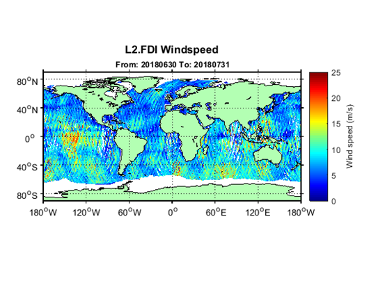
Caption: July 2018 Global Wind Speed Map from www.merrbys.co.uk
Monthly maps of wind speed over the oceans can be obtained from http://merrbys.co.uk/l2-windspeed-monthly-maps
TechDemoSat-1 was launched in 2014 and carried 8 payloads from different UK organisations. On successful completion of the satellite’s original mission, a life extension now allows the GNSS Reflectometry payload to be operated 24/7 continuously. On-board processed GNSS-R data is relayed to SSTL’s ground station in the UK and inverted for geophysical parameters using NOC retrieval algorithms for the estimation of near-surface ocean wind speed. Users have access to data from the past 3 years and new data is added daily with a latency of 30 days. Users can also register for a fast service allowing retrieval of data with a shorter delay - currently 48 hours, but with a target of less than 24 hours as the service matures.
The current service is a pilot demonstration showing the potential for a new source of wind and wave measurements from in orbit using a small satellite. In future, a constellation of low cost small satellites carrying enhanced instruments could provide measurements in near-real time to support weather and wave forecasting.
The TechDemoSat-1 satellite and payload were supported by UK Centre for Earth Observation Instrumentation and the UK Space Agency, and sponsorship from European Space Agency has allowed the release of data. Over 50 international journal papers have been published based on the use of the TechDemoSat-1 GNSS-R data. SSTL also provided the same GNSS Reflectometry instrument to the NASA CYGNSS mission, where 8 small satellites are using this technique to probe and analyse hurricanes.
ENDS
Press Contact:
Joelle Sykes, PR Manager, SSTL
Tel: +44 (0)1483 804243
Mob: 07775 000853
Email: j.sykes@sstl.co.uk
About SSTL
Surrey Satellite Technology Limited (SSTL) is the world's leading small satellite company, delivering operational space missions for a range of applications including Earth observation, science, communications, navigation, in-orbit servicing and beyond Earth infrastructure. SSTL designs, manufactures and operates high performance satellites and ground systems for a fraction of the price normally associated with space missions, and employs 500 staff working on turnkey satellite platforms, space-proven satellite avionics, optical instruments and new mission concepts.
Since 1981, SSTL has built and launched more than 50 satellites for 20 international customers, as well as providing training and development programmes, consultancy services, and mission studies for ESA, NASA, international governments and commercial customers. Our innovative approach is changing the economics of space.
Headquartered in Guildford, UK, SSTL is part of Airbus.
www.sstl.co.uk
About NOC
The National Oceanography Centre (NOC) is the UK’s leading institution for integrated coastal and deep ocean research. NOC undertakes and facilitates world-class, agenda-setting scientific research to understand the global ocean by solving challenging multidisciplinary, large scale, long-term marine science problems, underpinning international and UK public policy, business and wider society outcomes. The NOC operates the Royal Research Ships James Cook and Discovery and develops technology for coastal and deep ocean research. Working with its partners, NOC provides long-term marine science capability including: sustained ocean observing, mapping and surveying; data management and scientific advice.
The NOC operates at two sites, Southampton and Liverpool, with the headquarters based in Southampton.
Among the resources that NOC provides on behalf of the UK are the British Oceanographic Data Centre (BODC), the Marine Autonomous and Robotic Systems (MARS) facility, the National Tide and Sea Level Facility (NTSLF), the Permanent Service for Mean Sea Level (PSMSL) and British Ocean Sediment Core Research Facility (BOSCORF).
Download PDF
