
The innovative new datasets use reflected Navigation signals from small satellite TechDemoSat-1.
Surrey Satellite Technology Ltd (SSTL) and partner the National Oceanography Centre (NOC) have released new datasets that demonstrate how reflections of satellite navigation signals collected in space can be used to accurately map the extent of the sea ice in the Arctic and Antarctic.
The measurements were taken by an SSTL small satellite called TechDemoSat-1, launched in 2014, which carried the SGR-ReSI, an instrument designed to demonstrate accurate measurement of ocean wind speeds around the globe using GNSS reflectometry. With funding from ESA, NOC developed the algorithms to estimate the wind speed from GNSS reflections, and recently added the capability to discriminate between ocean and ice. By exploiting the way that GNSS signals are used as radar sources it is believed that the ice edges can be detected with a higher resolution than using passive sensing methods, and this information is potentially valuable for shipping and off-shore energy, as well as climate and polar ice research.
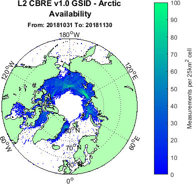
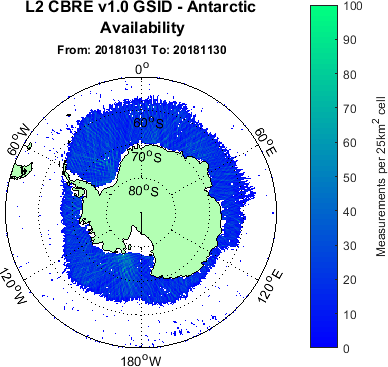
Images show the sea ice extent during November 2018 over the Arctic and Antarctic. The hole over the North Pole shows the high latitude limit of the TechDemoSat-1 satellite’s ability to collect GPS satellite reflections. The full set of Sea Ice detection data is available free of charge from data portal www.merrbys.co.uk
Phil Brownnett, Managing Director of SSTL, said “This is another important demonstration of the benefits of GNSS-Reflectometry for both commercial and scientific communities. SSTL, in collaboration with partners, has taken this new technique from feasibility to a world-leading capability which will see new missions uncovering further applications over ocean, ice and land.”
Giuseppe Foti, Senior Scientist of NOC, said “These recent results show how collaboration between academia and industry is critically important to improve our understanding of ocean and ice processes that have a global impact on our planet.”
The SGR-ReSI instrument from SSTL is flying on the 8-satellite NASA CYGNSS mission launched in 2016 to enable the measurement of hurricanes. The sensor can be carried on a very small satellite and a future constellation could offer low delay, high accuracy ice edge mapping, in addition to the other benefits GNSS reflectometry brings over land, ice and ocean.
SSTL is working on a number of projects to exploit GNSS reflectometry for different applications and the SSTL HydroGNSS concept for sensing land hydrographic climate variables using GNSS reflectometry has recently been down-selected for the ESA Scout mission opportunity.
ENDS
Notes to editor:
Full size accompanying images for this press release can be downloaded at the bottom of this page.
In the images below the colours indicate the density of measurements, rather than thickness of ice. In November, the polar ice sheets are changing – the north polar ice is increasing from its minimum, while southern polar ice is decreasing from its maximum, changes that can be observed in other monthly plots available on the MERRByS website. A single GNSS-R satellite can provide good coverage of the ice in one month, while additional satellites are required if a faster update is needed.
Press Contact:
Joelle Sykes, PR Manager, SSTL
Tel: +44 (0)1483 804243
Mob: 07775 000853
Email: j.sykes@sstl.co.uk
About Merrbys – Measurement of Earth’s Reflected Radio Navigation Signals by Satellite
Sea ice edge data-sets and other data products are available for free at www.merrbys.co.uk
The ocean is continually reflecting signals from radio-navigation satellites orbiting tens of thousands of kilometres above the surface of the Earth. These reflections carry the imprint of the sea-state; by capturing them from low Earth orbit with a GNSS receiver we can remotely sense the wind, waves and ice.
This service has been implemented by Surrey Satellite Technology with partners National Oceanographic Centre with funding from the European Space Agency.
About SSTL
Surrey Satellite Technology Limited (SSTL) is at the forefront of space innovation and is the world's leading small satellite company, delivering customisable complete mission solutions for Earth observation, science, communications, navigation, in-orbit debris removal and servicing and exploration beyond Earth infrastructure.
Since 1981, SSTL has built and launched more than 60 satellites for 20 international customers, as well as providing training and development programmes, consultancy services, and mission studies for ESA, NASA, international governments and commercial customers.
SSTL is well known for innovative missions such as the CARBONITE video imaging satellites, the NovaSAR S-band radar imaging satellite and the RemoveDEBRIS space debris removal technology demonstrator.
Headquartered in Guildford, UK, SSTL is part of Airbus.
www.sstl.co.uk
About NOC
The National Oceanography Centre (NOC) is the UK’s leading institution for integrated coastal and deep ocean research. NOC undertakes and facilitates world-class agenda-setting scientific research to understand the global ocean by solving challenging multidisciplinary, large scale, long-term marine science problems to underpin international and UK public policy, business and wider society outcomes.
The National Oceanography Centre is an independent self-governing organisation - a charitable company limited by guarantee. The NOC is funded by UK Research and Innovation to work on National Capability programmes, and manages on its behalf, the National Marine Equipment Pool - Europe’s largest fleet of autonomous and robotic vehicles, and two state of the art research ships RRS Discovery and RRS James Cook.
The NOC activities in this project were delivered by staff from the NOC Satellite Oceanography which delivers scientific research, consultancy and training in many aspects of ocean remote sensing. The team has long-standing expertise in GNSS-Reflectometry where NOC scientists are taking a leading role in the development of geophysical inversion strategies for the retrieval of surface parameters including ocean winds and sea-ice properties.
Download PDFImages
Download Hi-Res

Download Hi-Res