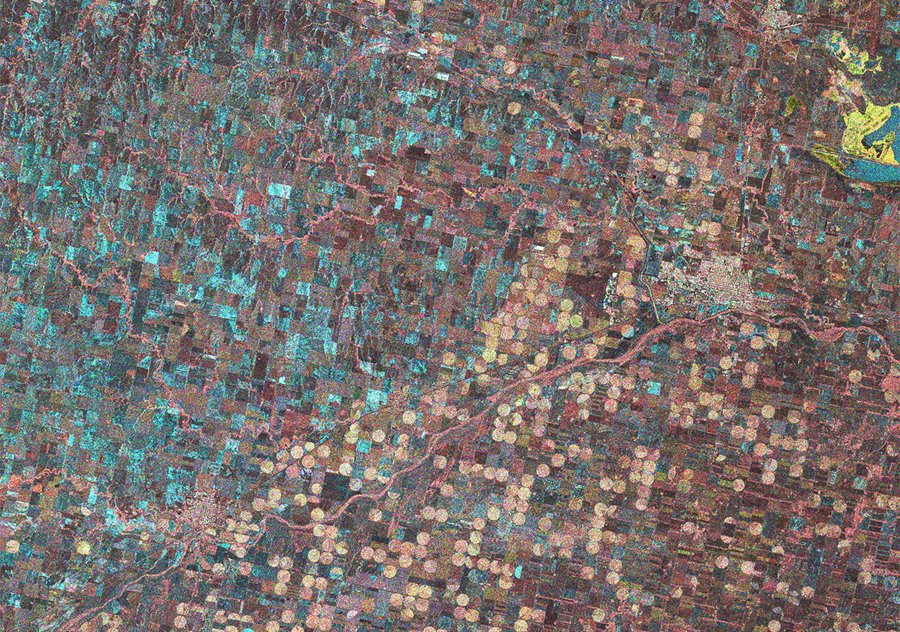
30m Resolution Triple Polarisation NovaSAR-1 image of an area in Kansas, USA: HH (Green), VV (Blue) and HV (Red) polarisation channels.
Combining the information in the received polarisation channels from NovaSAR-1 improves the ability to distinguish, and classify, different crop types or crops at different stages of growth. The dataset shown above, covering an area of Kansas, USA, highlights the combined information content of the HH, VV and HV channels by simply overlaying them as a false colour composite image.
The image dataset shows the use of central pivot irrigation, a method of crop irrigation in which equipment rotates around a pivot and crops are watered with sprinklers. A circular area centered on the pivot is irrigated, creating a circular pattern in crops when viewed by satellite.
View/download the image via our Media Gallery.
NovaSAR-1 was launched in September 2018 and is successfully providing valuable data to the NovaSAR-1 Mission Partners, supporting a range of applications. One of the key applications that NovaSAR-1 can address is agriculture. With its ability to see through cloud using Synthetic Aperture Radar, NovaSAR-1 can reliably provide imagery regularly throughout the growing season allowing crop growth and health to be monitored. Wide area swaths can support large area assessments and the high resolution mode supports detailed analysis of specific areas.
Operating at S-band the NovaSAR-1 radar can penetrate further into the vegetation canopy than C or X-band and therefore provide more information on a plant’s structure and the underlying soil conditions. Additionally SAR polarimetry provides enhanced information content over single polarisation imagery by emphasising differences in surface roughness and dielectric constant of distributed targets. Hence, variations in the structure of vegetation or in soil moisture mean land areas, which appear similar to the eye, can reflect each polarisation channel slightly differently.
Monitoring and management of agricultural yields and practices is vital for ensuring national and global food security and the imagery from NovaSAR-1 can support tasks such as crop identification, yield estimation, detection of areas affected by pests or disease, harvest date prediction and compliance monitoring.
NovaSAR-1 was designed and manufactured at SSTL, with the S-Band payload developed by Airbus Defence and Space in Portsmouth UK, and an Automatic Identification Receiver supplied by Honeywell Aerospace.
Mission partners for NovaSAR-1 data include the UK Space Agency, Australia’s Commonwealth Scientific and Industrial Research Organisation (CSIRO), the Indian Space Research Organisation (ISRO) and Republic of the Philippines’ Department of Science and Technology-Advanced Science and Technology Institute (DOST-ASTI).