The successful demo consolidates concept designs for a proposed land sensing ESA Scout mission, HydroGNSS
Surrey Satellite Technology Ltd (SSTL) has successfully demonstrated GNSS-Reflectometry (GNSS-R) from its 18kg DoT-1 satellite. SSTL has pioneered the new field of GNSS-R with successful payloads on board TechDemoSat-1 and the CYGNSS constellation, and is continuing to develop the technology and data analysis in pursuit of this new science. The latest GNSS-R payload on-board the DoT-1 satellite is incorporated within the new small form factor Core Avionics module integral to all SSTL’s future satellite platforms. This innovation paves the way for any SSTL satellite that can accommodate a nadir pointing antenna to become part of a GNSS-R small-sat constellation.
GNSS Reflectometry is an Earth observation technique that uses GNSS signals as L-Band radar sources, allowing the satellite to take measurements of ocean wind speeds, polar ice and hydrological land parameters, at a higher spatial resolution and an order of magnitude lower cost than other methods.
Phil Brownnett, Managing Director of SSTL, said “GNSS-R is a powerful new science that can contribute valuable data to help monitor changes in our global climate, and I am really pleased with the success of our DoT-1 demonstration. We now have an advanced instrument design and deep expertise in this new field and I am hopeful that SSTL’s HydroGNSS concept will progress to a full mission to support the global climate control challenge.”
This GNSS-R technology demonstration from SSTL’s DoT-1 satellite is also an important stepping stone for a proposed ESA Scout Mission Concept called HydroGNSS which comprises two 40kg satellites that collect data continually in near-polar orbits, taking hydrological measurements over the whole globe. The HydroGNSS mission concept makes advanced use of new GNSS Reflectometry techniques such as Galileo signals, dual polarisation, and coherent signal acquisition to measure 4 Essential Climate Variables (ECVs) over land: Soil Moisture, inundation, permafrost freeze/thaw, and biomass. HydroGNSS has been down-selected by ESA for a concept study, and the finally selected Scout mission will commence in 2021.
An animation illustrating the HydroGNSS mission is available to view on SSTL’s YouTube channel at https://youtu.be/30pemNtyBVA
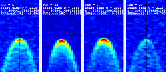
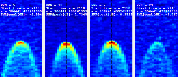
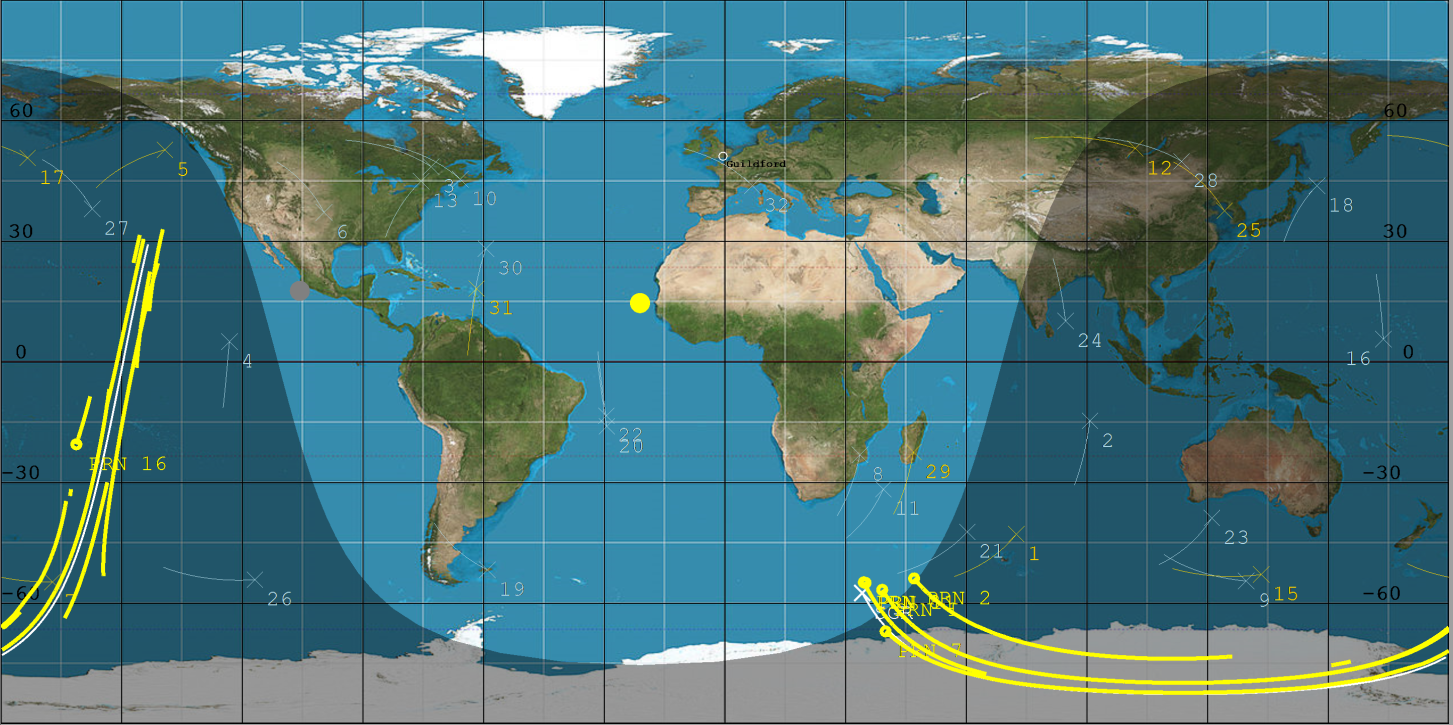
SSTL’s GNSS-R instrument collects and processes measurements into a “Delay Doppler Map” (DDM) that can be corrected and inverted into Level 2 products such as ocean wind speed, as has already been successfully demonstrated by the SSTL GNSS-R instruments on-board the TechDemoSat-1 and CYGNSS missions. The plot below shows results from data gathered by the DoT-1 satellite on 12th August 2020 and shows simultaneous “Delay Doppler Maps” from four separate GPS satellites. As this is a forward scattering technique, the stronger signals with redder peaks indicate a calmer ocean with lower wind speeds. Approximately 40 minutes of data were collected from the Pacific to the Antarctic to the Southern Ocean.
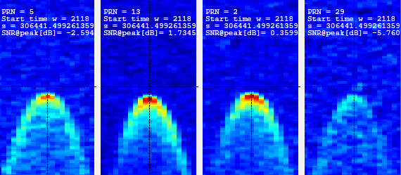
4 Delay Doppler Maps (DDMs) collected by DoT-1 that show signal reflections from 4 GPS satellites
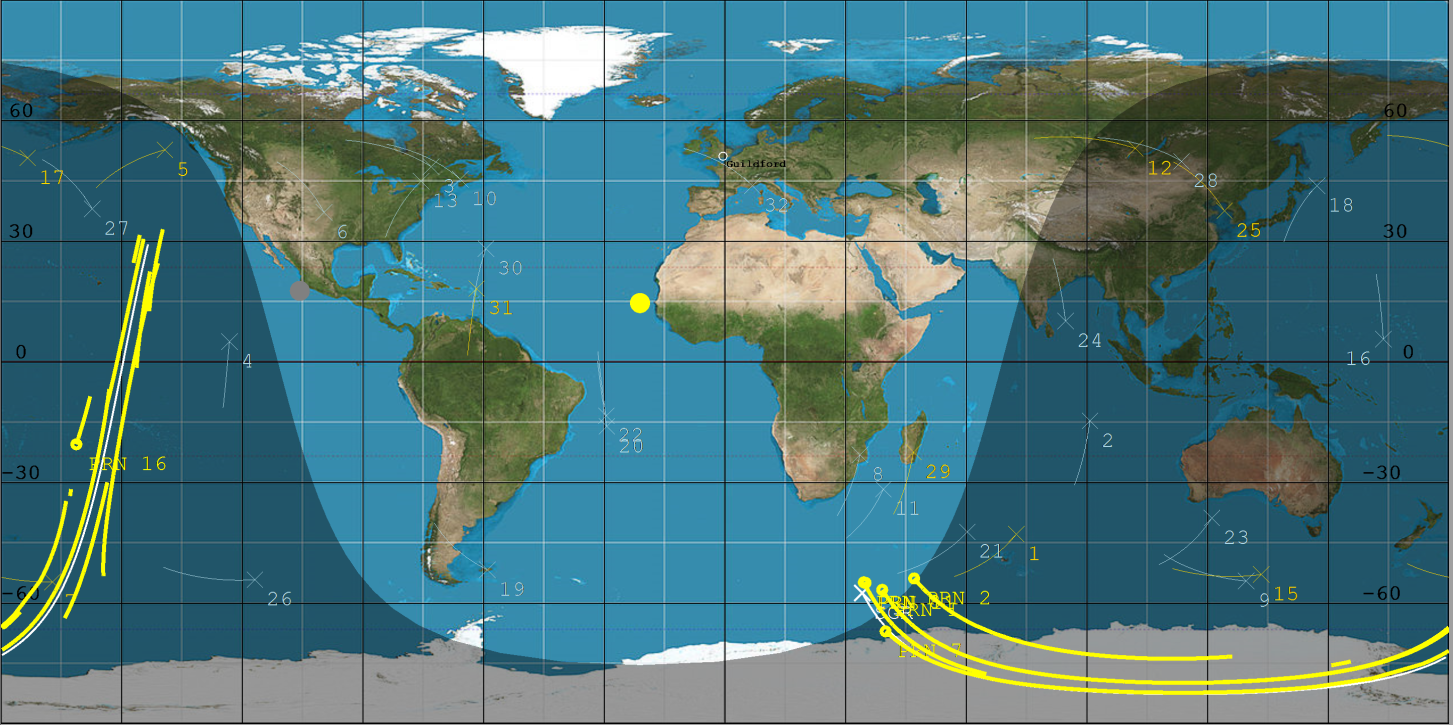
DoT-1 sub-satellite track (white) and GPS reflection tracks (yellow) collected during 40 minute data operation.
Data from the SSTL GNSS-R instruments on-board the CYGNSS mission have demonstrated the potential for soil moisture measurement by GNSS Reflectometry, and preliminary work shows that GNSS-R also has good sensitivity for Freeze-Thaw sensing in the active zone of permafrost. Unseasonal changes in the permafrost cycles could potentially release larger quantities of methane, which risks exacerbating global climate change. GNSS-R can also be used to assess biomass, a measure of forest density which acts as a vital sink for removing carbon dioxide from the atmosphere. In addition to longer term climate observations, soil moisture and inundation measurements from GNSS Reflectometry can provide important information for short term operational purposes, for example, towards Numerical Weather Prediction and flood warnings following rainfall events.
The development of SSTL’s new GNSS-R instrument was part-funded by the European Space Agency.
ENDS
Notes to editor:
Full size accompanying images for this press release can be downloaded at the bottom of this page.
An animation illustrating the HydroGNSS mission is available to view on SSTL’s YouTube channel at https://youtu.be/30pemNtyBVA
Press Contact:
Joelle Sykes, PR Manager, SSTL
Tel: +44 (0)1483 804243
Mob: 07775 000853
Email: j.sykes@sstl.co.uk
About SSTL
Surrey Satellite Technology Limited (SSTL) is at the forefront of space innovation and is the world's leading small satellite company, delivering customisable complete mission solutions for Earth observation, science, communications, navigation, in-orbit debris removal and servicing and exploration beyond Earth infrastructure.
Since 1981, SSTL has built and launched more than 60 satellites for 20 international customers, as well as providing training and development programmes, consultancy services, and mission studies for ESA, NASA, international governments and commercial customers.
SSTL is well known for innovative missions such as the CARBONITE video imaging satellites, the NovaSAR S-band radar imaging satellite and the RemoveDEBRIS space debris removal technology demonstrator.
Headquartered in Guildford, UK, SSTL is part of Airbus.
www.sstl.co.uk
Download PDFImages
Download Hi-Res
Download Hi-Res
