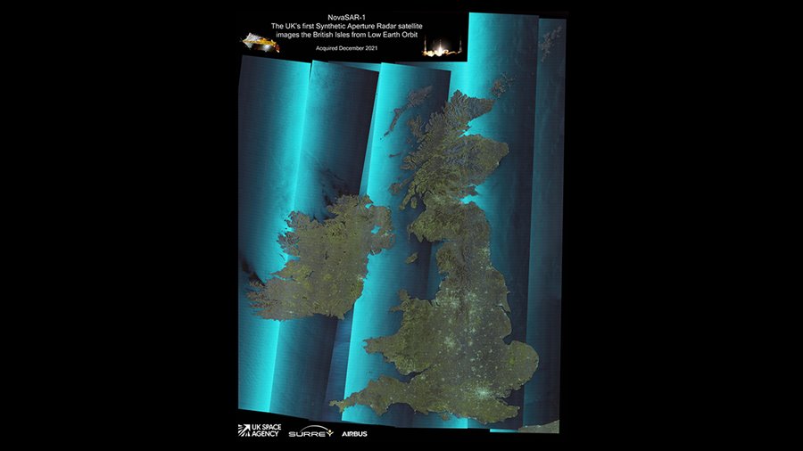
In December 2021, SSTL's NovaSAR-1 satellite was tasked to image the United Kingdom and the 7 downloaded images have been stitched together into a mosaic corresponding to an area of approximately 1500x1168 km (1.75 million square km) or 938 x 730 miles (685,000 square miles).
View/download the image in our Media Gallery.
NovaSAR-1 images using Synthetic Aperture Radar (SAR), a powerful tool for monitoring the Earth from space due to its ability to see through clouds and image the Earth night and day.
NovaSAR-1's mosaic image shows:
- Major cities and populated areas
- Offshore wind farms in the North sea and off Merseyside
- Key bridges (Severn Bridge, Dartford Crossing, Forth Bridge)
- Estuaries, lakes, lochs, tarns & loughs
- Shipping
- National Park areas (Scottish Highlands, Lake District, Peak District, Snowdonia, Brecon Beacons, Dartmoor, South Downs, Yorkshire Dales)
- Ocean Surface roughness variations (especially off West coast of Ireland)
- Major airports (Heathrow, Gatwick, Birmingham City, Manchester, Edinburgh
The imaging mode used was the Dual-Polar ScanSAR mode with a 195km swath width. This enabled the large area to be covered in just 7 acquisitions. NovaSAR-1’s Dual-Polar feature provides the (false) colour information, which discriminates very well between land and water, but also between different types of land cover. The resolution is 50m - this is much coarser than the 6m resolution that NovaSAR-1 can achieve but resolution was exchanged for swath width.
The large variation of ocean surface backscatter with incidence angle is very visible in each of the 7 images and is a feature of SAR imaging being a side-looking technique. Essentially, looking more ‘downward’ at the ocean causes a stronger reflection than looking at a more glancing angle.
There is also a finer ‘herringbone-like’ pattern visible in the ocean. This is to do with the ScanSAR technique used to form the image, where the radar rapidly switches between different beams in order to achieve a much wider image than with a fixed beam.
NovaSAR-1 was designed and manufactured by SSTL, with an S-Band SAR payload developed by Airbus Defence and Space in Portsmouth and an Automatic Identification Receiver supplied by Honeywell Aerospace. The SAR payload has a dedicated maritime mode designed with a very wide swath area of 400km to enable the monitoring of the marine environment, and will provide direct radar ship detection information simultaneously with AIS ship tracking data to assist with the identification and tracking of sea-going vessels. In addition to operating in maritime mode, NovaSAR-1 has been optimised with three additional imaging modes, including a six metre resolution imaging mode, for a range of other applications, such as flood monitoring and agricultural and forestry applications. The satellite has been designed to offer a high throughput of data, observing in a variety of polarisation combinations to additional information to acquisitions in the form of ‘colour’
NovaSAR-1 is the first SAR spacecraft to be manufactured entirely in the UK and is also the world’s first commercial SAR satellite to be operated at a 10:30 equator crossing time, providing time diversity for radar observations by affording increased daylight imaging opportunities in addition to night acquisitions.
Mission partners signed up for capacity from NovaSAR-1 include the UK Space Agency, Australia’s Commonwealth Scientific and Industrial Research Organisation (CSIRO), and the Indian Space Research Organisation (ISRO), the Republic of the Philippines Department of Science and Technology-Advanced Science and Technology Institute (DOST-ASTI) and Space-Eyes.LLC.